API User’s Guide
The SBN Survey Image Service (SIS) is deployed and available for PDS Small-Bodies Node survey holdings. Two data sets are currently available:
Near-Earth Asteroid Tracking (NEAT) survey
Asteroid-Terrestrial Last Alert System (ATLAS) survey
This guide explains how to use the SIS to access these data, whether you already know the data product you are interested in, or you want to search the database to inspect it’s holdings.
The API specification is defined with OpenAPI, and is available as Swagger documentation.
Why search the database?
Note
The primary means for accessing SBN’s survey holdings is through the CATCH tool. CATCH can search for known comets, asteroids, or fixed (Celestial) targets.
Although most users will use CATCH as the access point for SBN’s survey data, the SIS is appropriate in limited circumstances. For example, a user may want to identify data related to CATCH results, or may be curious about the general state of the data archived and available for a survey.
Summarize by collection and facility
The /summary API endpoint returns a list of all data organized by collection
and facility
[
    {
        "collection": "test-collection",
        "count": 808,
        "facility": "test-facility",
        "instrument": "test-instrument"
    },
    {
        "collection": "urn:nasa:pds:gbo.ast.atlas.survey.234:58475",
        "count": 1027,
        "facility": "ATLAS MLO 0.5m Telescope",
        "instrument": "STA-1600 10.5x10.5k CCD"
    },
    {
        "collection": "urn:nasa:pds:gbo.ast.atlas.survey.234:58476",
        "count": 134,
        "facility": "ATLAS HKO 0.5m Telescope",
        "instrument": "STA-1600 10.5x10.5k CCD"
    },
    {
        "collection": "urn:nasa:pds:gbo.ast.atlas.survey.234:58476",
        "count": 994,
        "facility": "ATLAS MLO 0.5m Telescope",
        "instrument": "STA-1600 10.5x10.5k CCD"
    },
    ...
]
In the above snippet, we see a “test-collection” data set that is used for
internal testing, and the first three ATLAS entries. The first is the Mauna Loa
telescope data from the urn:nasa:pds:gbo.ast.atlas.survey.234:58475 data
collection. See the ATLAS documentation for naming schemes. The next two are
data from another collection (…58476), separated into the Mauna Loa and
Haleakala telescopes. There are 994 data products from the Mauna Loa telescope
in the urn:nasa:pds:gbo.ast.atlas.survey.234:58476 data collection.
Find data products in a collection
The /query endpoint returns products matching the requested criteria. The
following fields are searchable:
Field |
Description |
Example |
|---|---|---|
collection |
PDS4 collection logical identifier (LID) |
|
facility |
Observing facility (telescope) |
ATLAS MLO 0.5m Telescope |
instrument |
Instrument (camera) |
STA-1600 10.5x10.5k CCD |
dptype |
Data product type |
image |
Only exact matches are returned.
To list all data products in the urn:nasa:pds:gbo.ast.atlas.survey.234:58475 collection:
{
    "count": 100,
    "offset": 0,
    "results":
        [
            {
                "access_url": "https://sbnsurveys.astro.umd.edu/api/images/urn%3Anasa%3Apds%3Agbo.ast.atlas.survey.234%3A58475%3A01a58475o0021o.fits?format=fits",
                "calibration_level": 1,
                "collection": "urn:nasa:pds:gbo.ast.atlas.survey.234:58475",
                "dptype": "image",
                "facility": "ATLAS MLO 0.5m Telescope",
                "instrument": "STA-1600 10.5x10.5k CCD",
                "obs_id": "urn:nasa:pds:gbo.ast.atlas.survey.234:58475:01a58475o0021o.fits",
                "pixel_scale": 0.000517261699601208,
                "target": "Sky"
            },
            {
                "access_url": "https://sbnsurveys.astro.umd.edu/api/images/urn%3Anasa%3Apds%3Agbo.ast.atlas.survey.234%3A58475%3A01a58475o0022o.fits?format=fits",
                "calibration_level": 1,
                "collection": "urn:nasa:pds:gbo.ast.atlas.survey.234:58475",
                "dptype": "image",
                "facility": "ATLAS MLO 0.5m Telescope",
                "instrument": "STA-1600 10.5x10.5k CCD",
                "obs_id": "urn:nasa:pds:gbo.ast.atlas.survey.234:58475:01a58475o0022o.fits",
                "pixel_scale": 0.000517256588879647,
                "target": "Sky"
            },
            ...
        ],
    "total": 1027
}
The first 100 matches are returned. To return the next 100, set the offset parameter to 100:
{
    "count": 100,
    "offset": 100,
    "results": [ ... ],
    "total": 1027
}
Get image data
To get the survey data, use the /images/{id} endpoint, where {id} is the
data product’s PDS4 logical identifier (the obs_id field in query results).
Return the image for the LID
urn:nasa:pds:gbo.ast.atlas.survey.234:58475:01a58475o0021o.fits:
Note
This will download a 140 MB data file.
ATLAS data are stored at SBN as compressed FITS files. The file should be
saved with the .fz extension to reflect this fact.
Get an image cutout
Return a cutout around a specific location in an image using the
/images/{id} endpoint with the ra, dec, and size options. This
example is for the NEAT survey:
To return a JPEG formatted image, use the format=jpeg option:
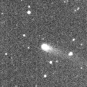
All image cutouts are reprojected to a new world coordinate system with a gnomonic projection at the center of the image. The reprojection uses nearest-neighbor interpolation. Users needed higher fidelity images instead use a FITS-formatted cutout.
Image metadata
FITS formatted image cutouts carry the original FITS header, unmodified except for WCS keywords. Image previews (JPEG, PNG) will contain a limited amount of WCS metadata based on the Astronomy Visualization Metadata Standard. The metadata are stored in the image file’s Extensible Metadata Platform (XMP) tags, and may be used to, e.g., overlay images in the Worldwide Telescope.
Archival metadata: PDS4 labels
Return the archival metadata associated with a data product using the
images/{id} endpoint with the format=label option:
<?xml version="1.0" encoding="utf-8"?>

<?xml-model href="https://pds.nasa.gov/pds4/pds/v1/PDS4_PDS_1L00.sch"
    schematypens="http://purl.oclc.org/dsdl/schematron"?>
<?xml-model href="https://pds.nasa.gov/pds4/disp/v1/PDS4_DISP_1L00_1510.sch"
    schematypens="http://purl.oclc.org/dsdl/schematron"?>
<?xml-model href="https://pds.nasa.gov/pds4/img/v1/PDS4_IMG_1L00_1890.sch"
    schematypens="http://purl.oclc.org/dsdl/schematron"?>
<?xml-model href="https://pds.nasa.gov/pds4/survey/v1/PDS4_SURVEY_1L00_1100.sch"
    schematypens="http://purl.oclc.org/dsdl/schematron"?>
<?xml-model href="https://pds.nasa.gov/pds4/ebt/v1/PDS4_EBT_1L00_1100.sch"
    schematypens="http://purl.oclc.org/dsdl/schematron"?>

<Product_Observational xmlns="http://pds.nasa.gov/pds4/pds/v1"
    xmlns:disp="http://pds.nasa.gov/pds4/disp/v1"
    xmlns:ebt="http://pds.nasa.gov/pds4/ebt/v1"
    xmlns:img="http://pds.nasa.gov/pds4/img/v1"
    xmlns:survey="http://pds.nasa.gov/pds4/survey/v1"
    xmlns:xsi="http://www.w3.org/2001/XMLSchema-instance"
    xsi:schemaLocation="http://pds.nasa.gov/pds4/pds/v1 http://pds.nasa.gov/pds4/pds/v1/PDS4_PDS_1L00.xsd  http://pds.nasa.gov/pds4/disp/v1 https://pds.nasa.gov/pds4/disp/v1/PDS4_DISP_1L00_1510.xsd  http://pds.nasa.gov/pds4/img/v1 https://pds.nasa.gov/pds4/img/v1/PDS4_IMG_1L00_1890.xsd   http://pds.nasa.gov/pds4/survey/v1   https://pds.nasa.gov/pds4/survey/v1/PDS4_SURVEY_1L00_1100.xsd  http://pds.nasa.gov/pds4/ebt/v1   https://pds.nasa.gov/pds4/ebt/v1/PDS4_EBT_1L00_1100.xsd">
    <Identification_Area>
        <logical_identifier>urn:nasa:pds:gbo.ast.atlas.survey.234:58475:01a58475o0021o.fits</logical_identifier>
        <version_id>1.0</version_id>
        <title>ATLAS reduced image 01a58475o0021o</title>
        ...
    </Identification_Area>
    ...
</Product_Observational>